离岸价格
Get Latest Price50 ~ 75 / Piece
|1000 Piece Minimum Order
国:
China
モデル番号:
MG350
离岸价格:
50 ~ 75 / Piece Get Latest Price
ロケーション:
-
最低注文量の価格:
50 per Piece
最低注文量:
1000 Piece
パッケージの詳細:
color box
納期:
15-20 days
供給能力:
200000 Piece per Month
支払いタイプ:
L/C, T/T
製品グループ :
-

China
連絡先担当者 wong
Shenzhen, Guangdong
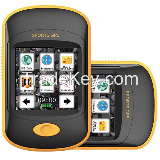
MG**0 Land measurement GPS is a simple and nice personal outdoor GPS device,It equipped with 2.*-inch TFT diaplay,Barometer,G-sensor and E-compass,and also supports ANT+ compatible Heart rate Monitor,With its compactdesign and light weight,It is suitable for many conditions,such as riding,climbing,running, fishing,etc.
IPX*7 Waterproof
The GPS can withstand accidental immersion in one meter of water
for up to *0 minutes
Barometer
Provide barometer pressure value,height etc.
Route Planning
You can plan your route by the APP in a computer,and upload it to
your personal land measurement GPS.Supported
file format:RTE,KML,GPX.
E-compass
Use E-compass to avoid getting lost when the GPS signal I not good
in harsh environments.
Fishing evaluation function
Provide weather forecast,Pressure system,fishing probability and
**-hours pressure chnge chart,so
that you always grasp the trend of changes in air pressure,adjust
the fishing location and waer depth,
and improve the chances of fishing.
GPS function
â—GPS Accuracy:***0meters in normal GPS mode.
â—Altitude measurement
â—Path Guiding:simulated route navigation
â—Speed/Elapsed tim/Distance etc.
Media function
â—MP3 and MP4 playback
â—Photo playback
â—Support e-book
Support ANT+ compatible Heart Rate monitor
Connect to ANT+ 2.4GHz compatible heart rate monitor,you can
see
â—Training instant information display
â—Real-time heart rate shows
â—Training interval indication(user can choose different training
interval)
â—Alert when HR isnt in specified zone
Sport analysis by the APP
You can plan a route through Google map.(maximum *0 routes with
each route maximum *0waypoints)
POI is for managing the marked POIs in the route.POIs can be
downloaded from the land meaurement GPS
and saved into files for backup.
Download tracks from the land measurement GPS,Click one route of
the track and it will show date,start time,end
time,duration,total distance,total waypoints of the route.
Share your sports tracks with your friends at some sports websites
| Display | 2.2″(**0***0 pixels)TFT Display Screen with TP |
| Positioning time | cold start:<*5s;warm start:<*0s;hot start:<1s |
| POI/Waypoints/Tracking Points | POI:*0;Waypoints:***0;Tracking Points:****0/Lines |
| Display data: | Speed,altitue,longitude,latitude and other GPS information can be pbtained by the APP |
| Navigation files format | support KML,RTE format files |
| Generating files format | generate KML, TRK format files |
| Path guiding | simulated route navigation |
| Fishing | provide fishing the best time |
| Data management | AP software management GPS,HRM data |
| Barometer | provide barometer pressure value,height etc |
| HRM(optional) | support ANT2.4GHz heart rate monitor |
| MP3/MP4 | support MP3/MP4 playback |
| Flash Menory | 4GB |
| Power supply | Li-polymer battery,operation time *0 hours(***0mAh) |
| Waterproof | IPX*6 |
| Size | *4(L)x*7(W)x*2.5(D)mm |
| operating temperature | **0°C~*0°C |
| Standard equipment | Mg**0 land measurement GPS,Manual,Bicycle bracket,USB cable,earphone |
| 国: | China |
| モデル番号: | MG350 |
| 离岸价格: | 50 ~ 75 / Piece Get Latest Price |
| ロケーション: | - |
| 最低注文量の価格: | 50 per Piece |
| 最低注文量: | 1000 Piece |
| パッケージの詳細: | color box |
| 納期: | 15-20 days |
| 供給能力: | 200000 Piece per Month |
| 支払いタイプ: | L/C, T/T |
| 製品グループ : | - |


