离岸价格
Get Latest Price0 ~ 10 ( Negotiable )
|1 Set Minimum Order
国:
China
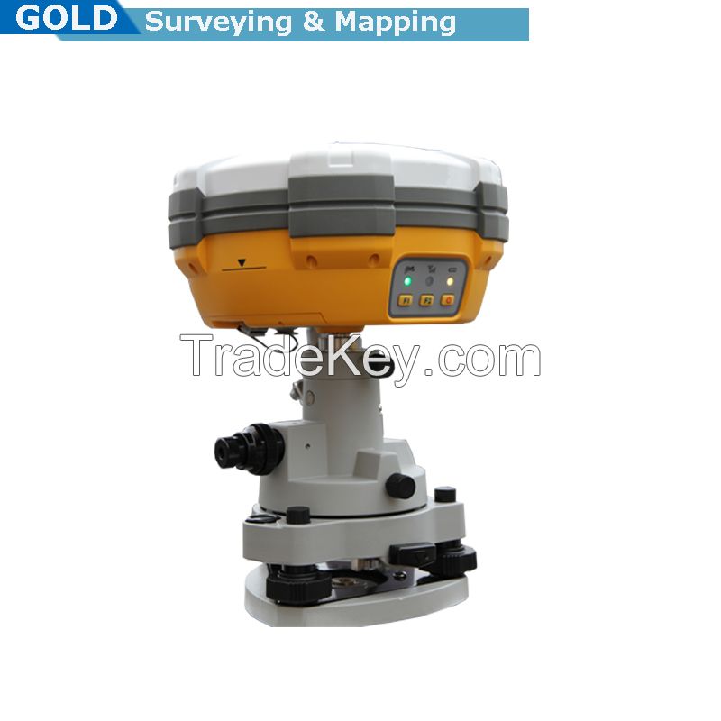
モデル番号:
V30
离岸价格:
0 ~ 10 ( Negotiable ) Get Latest Price
ロケーション:
-
最低注文量の価格:
-
最低注文量:
1 Set
パッケージの詳細:
Carton box
納期:
7-10 working days after receiving the payment
供給能力:
100 Set per Month
支払いタイプ:
T/T, L/C
製品グループ :
連絡先担当者 Gold
9F/10 Jintai building, Nanping dist, Chongqing, Chongqing
1.Construction Layout
2.Electric power transportation
3.CORS application
4.CORS site
5.Control survey
6.Data collection
7.Water Measurement
8.Construction Positioning (water)
Main Features:
Multi-constellation tracking
1. **0 tracking channels.
2. Supports GPS, GLONASS, GALILEO, BDS, SBAS.
3. NGS approved GNSS antenna.
Intelligent operation
1. Equipped with a smart speaker guiding the whole operation.
2. Multi one- functions make fieldwork easier, such as
auto
base setup by one , the rover can get fix solution once
it
is turned on.
Diversify RTK application
Optional transceiver UHF radio
1. The transceiver UHF radio enables the working mode to be
switchable between base and rover.
2. *-watt HI-TARGET internal UHF radio and *-watt Pacific Crest
TrimTalk© internal UHF radio are optional. Pacific Crest
TrimTalk©
internal UHF radio is compatible with other radios.
3. Removable internal UHF radio enables users to fix or
exchange
simply.
Seamless operation in CORS system
4. Built-in GPRS/GSM/3G module ensures that the V*0 works
perfectly with network RTK positioning.
Long-life battery
1. Powered by ***0mAh Li-ion battery.
2. Static working time *3 - *5 hours.
3. RTK Rover (UHF/GPRS/GSM) working time *0 - *2 hours.
4. RTK Base working time 8 - *0 hours.
Rugged and unique design
1. IP*7 dust/water protection.
2. Withstands *-meter natural fall onto concrete.
3. Rapid tracking and perfect avoidance or reduction of
obstruction
and multipath effect to ensure superior positioning capability.
Main specification:
Channel: **0
Signal tracking
GPS: L1 C/A, L2E, L2C, L5
Glonass: L1C/A, L1P, L2C/A, L2P
SBAS: L1C/A, L5
BDS: B1,B2
Bluetooth: YES
Positioning accuracy
Static and Fast Static GNSS surveying Horizontal: ±(2.5mm*1ppm
RMS); Vertical: ±(5mm*1ppm RMS)
Post processing Kinematic(PPK/Stop & Go)GNSS surveying
Horizontal: ±(1cm*1ppm RMS); Vertical: ±(2.5cm*1ppm RMS)
Initialization time: typical *0 minutes for base while 5 minutes
for rover
Initialization reliability:typical>*9.9%
Baseline length
Static: ****0km for low latitude area; up to **0km
Fast Static: <*0km; Stop & Go: <*0km; PPK: <*5km
Data storage: 1GB
Data download: COM/USB
Interval: 1s**0s adjustable
Elevation: 1°**0° adjustable
Data update rate: ***0hz
Communications: 2 RS***2 port; 1 USB port; 1 bluetooth port; 2
external DC power port
Dimension: *9.5cm * h*0.4cm
Weight (with battery): 1.3kg (incl.battery)
Water/dust proof: IP*7, 3m(9.*4ft) natural fall onto concrete
Working temperature: **0℃~**5℃
Storage temperature: **0℃~**5℃
Electrical: 2 pcs 7.4v ***0mAh lithium battery, supports ***8v
external DC power supply
Power consumption 3.2W
Working time ****5 hours
Software: Relevant software provided
| 国: | China |
| モデル番号: | V30 |
| 离岸价格: | 0 ~ 10 ( Negotiable ) Get Latest Price |
| ロケーション: | - |
| 最低注文量の価格: | - |
| 最低注文量: | 1 Set |
| パッケージの詳細: | Carton box |
| 納期: | 7-10 working days after receiving the payment |
| 供給能力: | 100 Set per Month |
| 支払いタイプ: | T/T, L/C |
| 製品グループ : | gps rtk system |


 Absolute Encoding Dual-axis Compensation Land Surveying Total Station")


