离岸价格
Get Latest Price( Negotiable )
|1 Unit Minimum Order
国:
China
モデル番号:
MM120
离岸价格:
( Negotiable ) Get Latest Price
ロケーション:
USA
最低注文量の価格:
-
最低注文量:
1 Unit
パッケージの詳細:
original package
納期:
1-2 weeks
供給能力:
100 Unit per Month
支払いタイプ:
T/T, L/C, Western Union
製品グループ :
連絡先担当者 Gloria
Zhenghua Road,Futian District, Shenzhen, Guangdong
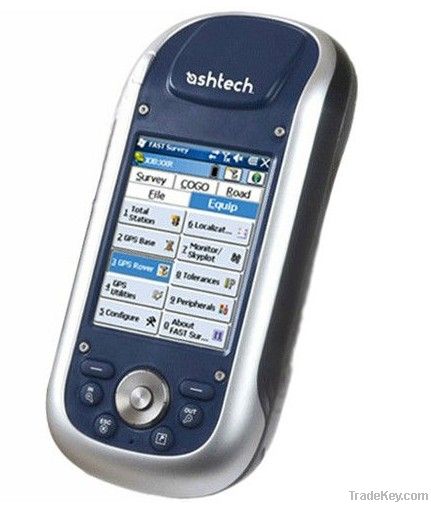
Ashtech Mobile Mapper**0 Handheld GNSS touchscreen GIS GPS Data collector
MobileMapper **0 is the newest generation of GNSS handheld mapping devices introduced by Ashtech. Designed for GIS data collection and mapping, it integrates an open operating system, built-in communications and the Ashtechs powerful BLADE technology. BLADE allows it to operate in extreme GNSS environments while maintaining the high accuracies desired by GIS professionals. Ashtech MobileMapper **0delivers state-of-the art features in a smart, compact, and lightweight handheld concept that gives users the ultimate field experience. Combined with MobileMapper Field proprietary software or Ashtech Business partners offerings, it brings the openness, flexibility and scalability needed to answer any mobile GIS requirements.
Complete solution:
The Ashtech MobileMapper software suite includes all GIS features
that professionals really need without the burden of complicated
and rarely used functions. It also provides a direct interface to
external sensors such as range laser finders.
Versatile application:
MobileMapper Field is the perfect solution for GIS data
collection, asset management, area measurements, maps creation
and update.
Easy to learn, Easy to use:
Ashtech software is very intuitive, requiring a minimum of user
training. It enables rapid deployment across the workforce for
large scale GIS data collection or maintenance.
Windows Mobile Openness:
With Windows Mobile 6.5 you may upload any necessary utility or
software on your MobileMapper **0, whatever suits your next job.
You can collect GIS/GPS points and maps via the GIS application
of your choice, either a third party software such as ESRI®
ArcPad® or the proprietary Ashtech application.
Software Choice:
Take advantage of the solutions that Ashtech Business Partners
are offering. Either in Forestry, Agriculture, Utility asset
management, Underground cable location, etc… the application
choice is large. Specific GIS software or hardware solution
combined with your MobileMapper **0 form an accurate all-in-one
mobile GIS solution, **0% matching your professional needs
| 国: | China |
| モデル番号: | MM120 |
| 离岸价格: | ( Negotiable ) Get Latest Price |
| ロケーション: | USA |
| 最低注文量の価格: | - |
| 最低注文量: | 1 Unit |
| パッケージの詳細: | original package |
| 納期: | 1-2 weeks |
| 供給能力: | 100 Unit per Month |
| 支払いタイプ: | T/T, L/C, Western Union |
| 製品グループ : | handheld GPS/GIS |


